In August 2019 Ralph and I visited Western Australia’s Pilbara region.
There is a connection in these parts with RGSQ’s founding President A.C. Gregory. His younger brother, Francis Thomas Gregory, also an explorer, led a party in the Barque Dolphin and landed on the Burrup Peninsula near Dampier in May 1861. A plaque at Hearson’s Cove commemorates his landing. Although the object of this expedition was to assess the suitability of the area for the cultivation of cotton, F.T Gregory’s reports led to the establishment of the north-west pastoral industry.
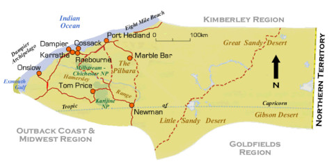
Of course, WA is so large that even just doing a circuit from Karratha-Dampier-Onslow-Tom Price-Karijini national Park-Marble Bar-Port Hedland-Karratha we clocked up approx. 3000km. The Geography of the Pilbara is amazing – the seemingly incongruous juxtaposition of the stunning and globally significant ancient geology and Aboriginal rock-art with the enormous scale and wealth of 21st century resource developments both inland and offshore.
BIFs - The Pilbara craton contains some of the oldest rocks on the surface of the planet representing one of the world’s best preserved fragments of ancient continental curst. Formed during the earliest part of Earth’s history, in the Archean, parts of the Hamersley Plateau and Karijini gorges date back to 3.7 billion years ago, around the time when life on earth first emerged. The BIFs - banded iron formations – are unique sedimentary rocks of biochemical origin which likely formed by the precipitation of iron and silica in seawater when the area was submerged. BIFs consist of alternating layers of iron oxides and shale, chert, tiger eye or jasper ranging from only a few centimetres to metres thick. These formations have been stable for very long periods and are highly resistant to weathering – thus the layering one sees in the landscape is still pretty much as it was when laid down under the sea.
Fe(iron) NaCl (salt) NG (natural gas) Incongruously adjacent to, but derived from the ancient geology are the massive mining and extraction developments of iron ore, manganese other minerals, salt and offshore natural gas in the Pilbara and Hamersley region. Driving around one encounters road-trains with 4 or 5 trailers carrying ore to the ports. The excellent highways often run parallel to railways along which the kilometre-long trains transport ore to Dampier, Wickham and Port Hedland. Northwest shelf natural gas is piped undersea over 100 kilometres to coastal liquefaction plants at Dampier and Onslow. From there it is processed and shipped out mostly to China & Japan. The salt mines supply 99% of Australia’s industrial salt & domestic table salt for our fish‘n chips ! So, we were fortunate to be in Karratha for the annual FeNaClNG Festival which is just the iconic Ekka with lots of local food, crafts and entertainment.
References:
Copp, Iain (2017) Geology and Landforms of the Pilbara WA Dept. of Parks and Wildlife
Map of Pilbara - Australian Travel and Tourist Network. https://www.atn.com.au/wa/north/pilbara-roadmap.html